
Cyclone Akvan Moves Towards Odisha, AP Braces for Heavy Rain
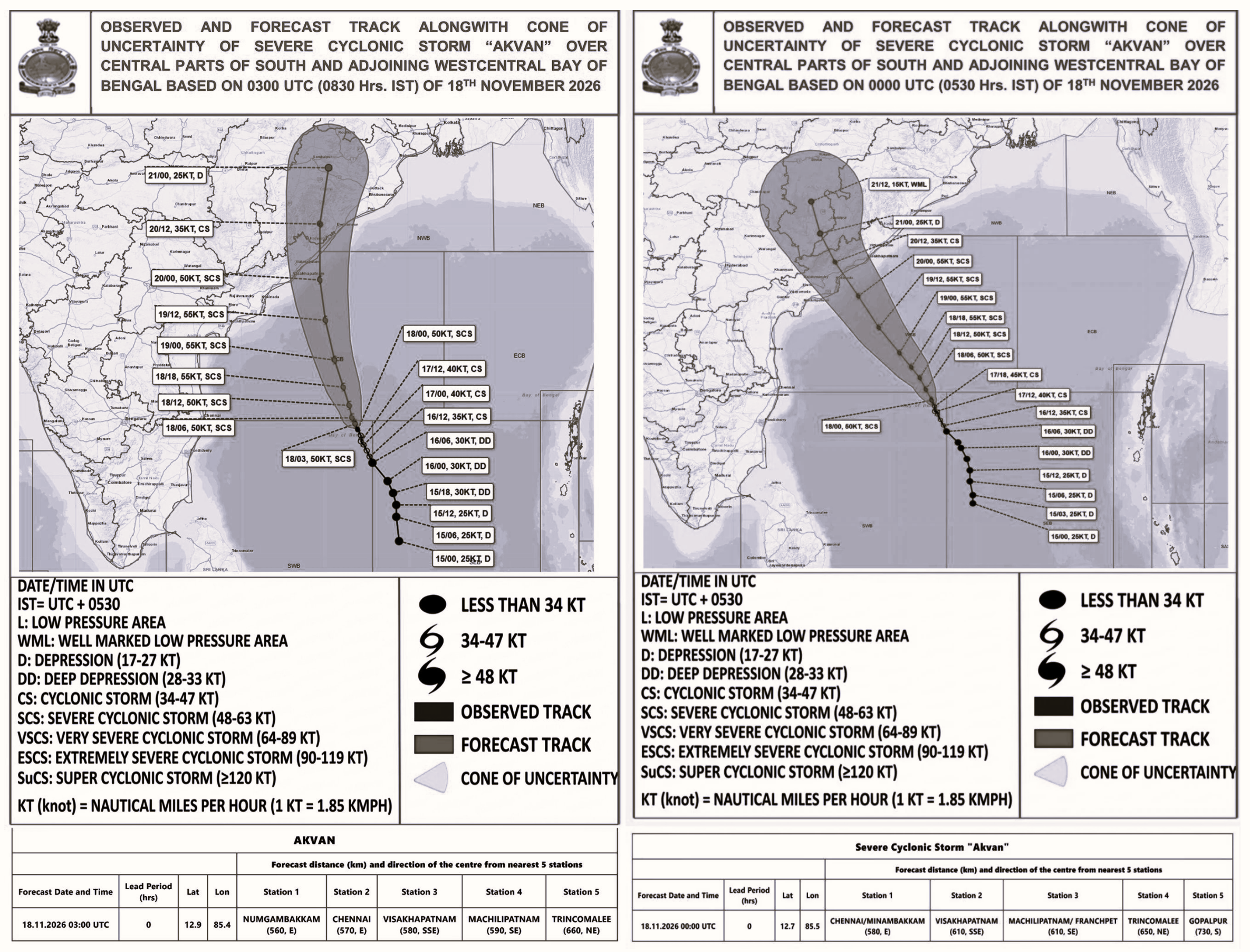
Cyclonic Storm Akvan is moving north-northwestwards over the Bay of Bengal, with the India Meteorological Department (IMD) forecasting a possible crossing between the North Andhra Pradesh–Yanam and South Odisha coasts around noon on November 20. The latest coastal bulletin places the likely crossing corridor between Narsapur and Puri, with maximum sustained wind speeds of 90–100 kmph and gusts reaching 110 kmph. Despite changes in its projected trajectory and a reduction in the expected intensity compared with earlier forecasts, several coastal districts remain vulnerable to extremely heavy rainfall, strong winds and possible inundation. Railway operations have also been affected, with the East Coast Railway rescheduling 10 trains as a precautionary measure.
The cyclone's projected path has undergone several revisions, initially indicating a possible crossing between Nellore and Tuni before shifting towards Central Andhra Pradesh and subsequently the Narsapur–Puri corridor. Earlier forecasts suggested a Very Severe Cyclonic Storm with winds of 120–130 kmph and gusts up to 145 kmph, but the latest IMD assessment indicates a Severe Cyclonic Storm with winds of 90–100 kmph.
Independent weather analysts have described Akvan as an unusually erratic system. Telangana Weatherman highlighted four changes in the forecast track, while Andhra Pradesh Weatherman reported a deteriorating, fragmented cloud structure. Moderate wind shear, dry-air intrusion from the southwest and the system's slow movement between two atmospheric ridges could contribute to further weakening. An independent assessment of 102 ECMWF and GFS model projections indicated 33% likelihood of an Andhra Pradesh impact, 25% towards Odisha–West Bengal and 41% weakening over the sea.
However, the IMD has warned of isolated extremely heavy rainfall of 21 cm or more in parts of coastal Andhra Pradesh and Odisha on November 19 and 20. Eastern Telangana could also receive heavy rainfall. A storm surge of 0.5–1 metre above astronomical tide may inundate low-lying areas of West Godavari, Konaseema, Kakinada, Vizianagaram, Srikakulam and Visakhapatnam, besides Ganjam and Puri. Offshore waves could reach 9–14 metres and exceed 14 metres during the peak period.
The Andhra Pradesh government has kept 13 NDRF and 11 SDRF teams ready, activated control rooms and prepared evacuation arrangements. Odisha has also intensified relief preparations, including cyclone shelters, drinking-water arrangements and precautionary evacuations. Fishing operations have been suspended in affected sea areas.
Meanwhile, East Coast Railway has rescheduled 10 trains operating on November 19 and 20. Delays range from two to eight hours, affecting services including the Charlapalli–Shalimar, Secunderabad–Howrah Falaknuma and Visakhapatnam–Amritsar Hirakud Express trains. The Visakhapatnam–Kirandul Express pair has also been reported cancelled on both days. Railway Minister Ashwini Vaishnaw reviewed preparedness, with emergency war rooms and restoration teams activated. The Chennai–Yangon weekly flight was also reported cancelled in both directions.