

NASA-ISRO Nisar Satellite Reveals Venezuela Quakes Shifted Ground By Two Feet
The Nisar satellite has delivered forensic proof of the devastation wrought by the June 24 earthquakes in northern Venezuela, revealing the terrain wrenched sideways by nearly sixty centimetres, close to two feet, in the nation's deadliest seismic catastrophe in 126 years.
A magnitude 7.2 foreshock struck first, followed a mere thirty nine seconds later by a punishing magnitude 7.5 mainshock. The disaster has since claimed more than 5,000 lives, injured over 16,700 people, and left tens of thousands still missing across Trujillo, Yaracuy, Carabobo, Aragua and Miranda. In La Guaira state alone, roughly eighty per cent of buildings collapsed or were rendered uninhabitable, displacing tens of thousands of families and leaving many camped in tents or on open ground for weeks. Unicef has flagged some 680,000 children as needing humanitarian assistance, while relief workers report worsening water shortages and disease outbreaks in the hardest hit communities around Caracas.
This was the maiden real world deployment of Nisar's Urgent Response system, engineered to funnel critical radar imagery to disaster teams within twelve to twenty four hours, a turnaround that proves decisive when rescuers must allocate scarce personnel and equipment amid fragmentary, chaotic reports on the ground. Because the radar penetrates cloud cover and functions equally well in darkness, it delivered usable data irrespective of weather. Analysts compared pre quake scans from June 13 and 18 against post quake images from June 25 and 30 using InSAR technology, with the initial maps later refined using precise orbital data within one to two days.
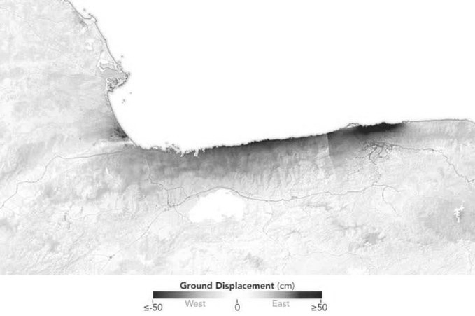
The satellite's displacement map, released by NASA, renders this movement in a striking colour scale running from deep blue, marking ground that shifted west by fifty centimetres or more, through pale neutral tones near zero displacement, to deep red, marking ground that shifted east by fifty centimetres or more. On the map, a sharp pocket of red and orange hugs the coastline near the Caracas area, showing the ground there lurched sharply eastward, consistent with the sixty centimetre peak displacement scientists recorded. Just beyond it, a broad blue band stretches along the coast further east, showing that section of ground moved the opposite way, westward, in the classic tug of war pattern of a strike slip fault. Further inland, the terrain fades to pale, near white tones, signalling minimal ground movement away from the rupture zone.
Scientists trace the destruction to decades of pent up strain along the San Sebastián and Boconó fault networks straddling the Caribbean and South American plates. Nisar's angled 40 degree viewing geometry, born of a joint Nasa ISRO engineering triumph launched in July 2025, allowed scientists to disentangle both horizontal and vertical crustal motion with rare fidelity. The USGS has since leaned on this data to sharpen its finite fault model, reconstructing precisely how the rupture tore offshore before slicing back onshore near the capital.